
Day Seven – Traveling Again

Cheri and I were on the road again heading for Dingle, Ireland, leaving Sarah behind for one more day in Dublin. She had to head back to London to pack up the exhibit and ship her photograph out. We used a taxi for a change, dropped Sarah off at the Tourism Office and headed for the Dublin Heuston Rail Station.
We boarded an Irishrail train to take us to Mallow where we had to change to a train bound for Kilarney. Fortunately in Mallow we got off the first train, crossed the platform and got right on the second train.
Upon arriving in Kilarney we tried to follow the signs around to the bus station and we had our first experience with signs and directions in the countryside of Ireland. The first sign, at the exit from the train station, pointed us down a sidewalk towards town. That was the last sign or directions we saw. We went down the hill, came to the entrance road for the train station and nothing telling us to head left or right. Fortunately—so we thought—there was a sign to the Tourist Information Center pointing downhill to the left. So we took our bags and headed in that direction…and it was beginning to rain. We went about a quarter mile and came upon an Irish Cultural Center, which turned out to be more of a community center, and I asked someone about the shuttle bus to Kerry County Airport (where we would pick up the rental car). She wasn’t sure, but pointed further downhill and said, “there is a Tourist Information Center down there someplace…or there is the bus station on the other side of the train station…just pass through the shopping mall and the bus station is at the other end.”
We opted to go back towards the train station, we found the mall—it was a small mall—and the bus station. It appeared we’d have found it by originally turning to the right, but again there were no other signs or directions—a trend we found several times.
The bus took us over the back roads—or actually what turned out to be some of the primary roads—to the airport and Avis rental. We picked up a Ford Moreno, a five speed manual sedan with a turbo-diesel engine. It had great pick-up and was fun to drive…with the driver’s seat on the right side.
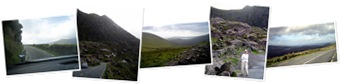
We took off out of the airport being conscious of driving on the left side of the road and headed for Dingle. I drove for the first 45 minutes with Cheri navigating. With only one side trip, another one of those sign things, we were soon at Conner Pass through the mountains and over to Dingle. Cheri took over driving at this time and we started climbing up into the mountain pass.

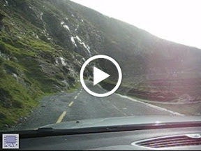
You can see the bay and valley behind us as we started to head into the pass. Below is an album link to show you the pictures taken during our stops along the way—this is the first try at using the Windows Live album approach and if you click on the slide show link it has a nice presentation of the pictures; give it a try. Someone offered to take a picture of us at the top of the Pass and you can see the valley we came up from behind us. Below this photo you can see the view looking other direction towards Dingle.   The picture to the right is the view from our room at the bed and breakfast (Heaton’s Guest House). You can see the Dingle sign to the lower left between the bushes and a tree. We were about 800 yards from the village so it was easy to walk back and forth into town. We asked for some thoughts on a place to eat dinner and you can see the place we settled on below.  |  To experience what it is like to be a passenger sitting on the left front side while going up a mountain road, click on the video photo below. Also remember that this is a two lane road with buses and large trucks going in both directions.
We pulled into Dingle and found a beautiful little fishing town that has a large tourism industry as well.   We had a great meal here and the restaurant is well known for its seafood.  |
Following dinner we decided to head back to the B&B and get a good night’s rest before spending the next day exploring. This is the view we had on the walk back from the village.

Day Eight – Exploring the Islands
After a great breakfast the next morning we walked back into the village and asked at the Tourist Center about tours out on the Blasket Islands. It turned out that the ferry was running from a different point further out on the peninsula. So we walked back to the B&B to pick up the car and headed out to explore the coastal road.
As we drove along we came upon little turn outs and view points along the way. Below is an album of our trip to the point.
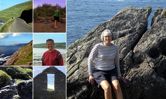
It took us a couple missed signs—or non-existent signs—which gave us some wrong turns and exploration of even smaller roads before we found the ferry to Blasket Island. The ferry wasn’t quite what one would normally think of as a ferry. We all put on life jackets and climbed from a slippery landing on to an Avon to transfer out to a larger boat. To the right you can see the landing point, well actually, it is around one of those rocks and we needed to wait a few minutes for the swells to die down before making a landing. As it was we ended up surfing down one of the swells and timing the turn around the rock to head in to the landing. While waiting to head in we did see some seals around the boat and you can see the head of one in the picture below.   |  You can see Cheri on the larger boat to the left and we soon headed out through the swells to the island. The crossing was fun and we had some good eight foot swells which had a couple of our fellow adventurers feeling quite queasy, but Cheri and I had no problems.   As we climbed up from the landing we went by some of the ruins from the days that people lived on the island year round. There are now a few summer homes on the island, but only a handful of people at any one time.  There were several sheep paths and climbing paths along the island. We started up one of the paths and I managed to get a picture of Cheri coming up the trail with the mainland of Ireland behind her. We made our way to one of the peaks and the picture in the middle of the collage below is when were at the top—once again the benefit of the gorilla tripod. |

The scenery was beautiful and we had a great time hiking around. We did have to watch our step in some places…the trails do follow close to some of the cliffs.
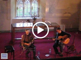
| As we headed back to the mainland we had to make the Avon to boat to Avon transfers and headed back to the landing. You can see the landing to the right and the trail built into the side of the hill to climb back up to the car. We got back to the B&B with enough time to shower and get ready to head out to a pub for dinner. Then it was off to an old church that has been made into a community center for a Folk Music show.  |   |
It was a great show and you can see and hear a video of some of the performance by clicking on the picture below. The man playing the pipes on the left commented that when he plays he always looks unhappy. He said, “It’s not because I’m concentrating or unhappy…when I was a boy my priest said something is a sin only if you take pleasure in doing it…”.
 |
| From Day Eight |
This day was an outstanding adventure in this trip of adventures!

1 comments:
You people really and truly disgust me. I may have to stop reading these blogs out of pure jealousy and hatred. I wish I'd been there!!!
Post a Comment